
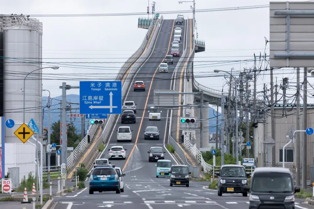
You’ve probably seen the photo even if the name means nothing to you. A wall of concrete rearing up into the sky, cars seemingly stuck to it like they’re about to crest the first drop of a rollercoaster. That’s the Eshima Ohashi Bridge in Japan, and the reality is a good deal tamer than the picture lets on.
People call it the “Rollercoaster Bridge”, or sometimes the “Bridge to the Sky”, and in photos it really does look like something off a theme park map. But the actual gradients are pretty ordinary: 6.1% on the Shimane side where Matsue sits, and 5.1% over on the Tottori side near Sakaiminato. In plain degrees that’s roughly 3.5° and 2.9°. Japan capped road gradients at 12% back in 1971, so even the steeper side comes in at about half the legal limit. Hardly the stuff of nightmares.
Why it looks so terrifying
It comes down to the lens. Almost every famous shot is taken from a fair distance on the Matsue side with a telephoto, which flattens the scene and pulls the bottom and top of the bridge together until it reads as a near-vertical climb. Get in a car and drive it, and the effect just disappears.
And here’s the thing that rather undercuts the legend: it isn’t even the steepest bridge going. A couple of its near neighbours edge it, and so does at least one famous crossing on the other side of the world:
| Bridge | Location | Length | Max gradient |
|---|---|---|---|
| Eshima Ohashi | Shimane/Tottori, Japan | ~1.7 km | 6.1% |
| Namihaya | Osaka, Japan | ~1.7 km | 6.9% |
| Sakaisuido | Tottori/Shimane, Japan | ~0.7 km | 7.25% |
| Storseisundet | Atlantic Road, Norway | 260 m | ~8% |
Eshima Ohashi only out-famouses them thanks to one well-timed car advert. Norway’s Storseisundet Bridge pulls almost exactly the same stunt: its curving hump hides the far side of the deck, so from the right spot the road looks like it launches straight into the sea — which is how it earned the nickname “the drunk bridge”. And to put 6.1% in perspective, the steepest street in the world, Baldwin Street in Dunedin, New Zealand, runs to roughly 34.8%. There’s a fitting Japanese nickname for a slope like this, betabumi-zaka, which translates as something close to a “pedal-to-the-metal hill”. Confusingly, it’s also called the “Ramen Bridge” — nothing to do with noodles. “Ramen” here comes from the German Rahmen, meaning frame, because it’s a rigid-frame bridge.
Built for ships, not thrills
All the drama is really a by-product of the engineering. The bridge went up between 1997 and 2004, and it had to clear big ships of up to 5,000 tonnes passing underneath, which is why it climbs to around 45 metres above Lake Nakaumi. It’s a dual-lane concrete rigid-frame bridge, 11.4 metres wide and a little over a mile long, with a 250-metre central span joining Matsue and Sakaiminato. That makes it the largest rigid-frame bridge in Japan and the third largest in the world.
Before it existed there was an old drawbridge on the spot, and it was a proper headache. Whenever a ship came through, traffic stopped for seven or eight minutes. Anything over 14 tonnes was turned away, and no more than 4,000 vehicles could cross in a day. The new bridge did away with all of that, and these days around 14,000 vehicles cross it daily without anyone giving it a second thought.
The advert that made it famous
Ironically, the illusion is exactly what made it a star. Daihatsu drove its little Tanto Custom up the slope in a TV advert — no CGI involved — to prove that lightweight kei cars aren’t as feeble on hills as people assume. The clip travelled around the world, and visitors have been turning up to photograph it ever since.
Visiting the bridge
It’s an easy detour if you’re already in the San’in region. The nearest station is JR Sakaiminato, about a 30-minute walk or a 10-minute drive away. Miho-Yonago Airport is also roughly 10 minutes by car, and if you’re driving the San’in road network it’s about 45 minutes from the Yonago IC exit. Coming from further afield, the usual route from Tokyo is the Shinkansen to Okayama and then the Limited Express Yakumo across to Matsue (around six hours), or the overnight Sunrise Izumo sleeper. From Osaka it’s closer to four.
You don’t have to drive it, either. There’s a path, so you can walk or cycle across — and that’s arguably the better way to do it, because from the crest you get the view the drivers miss: Lake Nakaumi spread out below, Daikon Island sitting in the middle of it, and Mount Daisen off in the distance on a clear day. One thing to keep in mind: it’s a working road, so stick to the path and watch for the warning signs.
How to get the famous photo
The gravity-defying shot only works from one direction. You want to be on the Matsue (Shimane) side, far enough back that a telephoto lens can compress the road into that vertical-looking climb — a longer lens and a tripod both make a real difference. A commonly used spot is along Prefectural Road 338 near the Kotobuki Bussan shop, with a FamilyMart close by; parking is tight, so the convenience stores tend to be the practical option.
Light matters more than you’d expect. Early morning gives you soft gold and a little mist on the hills behind; late afternoon on a clear day throws the pale concrete against a hard blue sky. If you can time it so a lorry or bus is starting the climb, even better — it adds scale and makes the slope look more absurd still. The bridge is lit at night, too, if you fancy something different.
What else is nearby
If you’re making the trip, the area rewards a proper day out. Sakaiminato is the hometown of Shigeru Mizuki, creator of GeGeGe no Kitaro, and its main street is lined with bronze statues of his yokai characters. Over on the Matsue side you’ll find Matsue Castle, one of only a handful of original castles left standing in Japan. And Daikon Island, just off the Shimane shore, is known for its peony and hydrangea gardens.
Is the Eshima Ohashi Bridge really that steep?
No. It looks near-vertical in photos, but that’s a telephoto trick. The real gradients are 6.1% on the Matsue side and 5.1% on the Sakaiminato side — roughly 3.5 and 2.9 degrees.
Can you drive across it?
Yes. It’s an ordinary two-lane road, and despite the photos the climb is gentle. You can also walk or cycle across.
Is it safe?
Very. It’s been open since 2004 with a near-spotless record. The fear it inspires is almost entirely down to how it’s photographed.
Where’s the best place to photograph it?
From the Matsue (Shimane) side, using a telephoto lens from a distance — around Prefectural Road 338 near the Kotobuki Bussan shop and FamilyMart.
How do you get there?
The nearest station is JR Sakaiminato (about 30 minutes on foot, 10 by car). It’s roughly 10 minutes from Miho-Yonago Airport and 45 minutes from the Yonago IC.